01.24.24 Dune Restoration 2024
Topic: Dune Restoration 2024
Guest Speakers: Michael Poff, PE, President, Coastal Engineering, Inc
Matt Logan, Charlotte County Projects Manager
Presented by: Palm Island Estates Association Inc. (PIE)
www.palmislandestates.org
and
Bocilla Islands Conservancy, Inc. (BICI)
www.bocillaislandsconservancy.org
Date: January 24, 2024, at 10:30 a.m.
Location: Palm Island Resort Clubhouse – Thank you!
On Wednesday, January 24th, PIE’s Info Central, in partnership with Bocilla Islands Conservancy, presented a fact-filled program on Charlotte County Beach Restoration and Inlet Management Projects, including the topic of dune restoration. Heading up the program was Michael Poff, P.E., President of Coastal Engineering Consultants, Inc., who has been involved in restoration projects on our islands since the late 1990’s. Mr. Poff was joined by Matt Logan, Charlotte County Project Manager who has been in charge of Charlotte County beach projects for 10 years.
Following is a very brief synopsis of the remarks made by Mr. Poff and Mr. Logan. A recording of the meeting is located below, and we encourage you to watch it to learn the history of beach renourishment here on Palm, Knight, and Don Pedro Islands — as well as on Manasota Key — the methods of dredging and placing the sand on the beaches, and the past dredging of Stump Pass. Additionally, there was a Q&A session at the end of the presentation and any questions you may have may have been answered at that time.
The current project will replace approximately 181,000 yards of sand along the beach from Stump Pass to Don Pedro State Park. It will cost approximately $7.67 million with approximately $4.14 million being contributed by FEMA, $1.6 million coming from the State of Florida, and the remainder being paid through the local MSBU/MSTU. The goal is to put the beach back as it was prior to Ian, Nicole, and Idalia, not only by raising the elevation of the sand, but also by replacing the dunes as they were prior to the storms. The dunes also will be replanted as they were. The project is currently in the permitting process, and it is hoped that the final design phase will occur June-July, the bid process will occur August – October and the construction process will begin in November. It is hope that it will be finished by February 2025, prior to bird nesting season.
It was explained that in order to obtain federal and state funds to share the costs of the renourishment projects, it is required that public accesses to the beaches be provided. We have 5 public accesses on N Gulf and S Gulf and an additional requirement is that each public access must have a certain number of parking spaces within ¼ mile of that access. If the accesses and associated parking are not maintained, the state and federal cost sharing will not be available, and islanders will then be responsible for 100% of renourishment costs rather than the current approximate 13% share.
Beach-Side Boundary Lines:
Finally, an explanation was given of what constitutes the beach-side boundary line for private property, i.e. high mean water line vs. erosion control line. On our islands the erosion control line is the private ownership boundary. This line was established prior to the first renourishment project in 2003 in order to receive public funding. At that time the beach was severely eroded. The surveyed line was the mean high tide line prior to commencement of the project and that became the property line for all Gulf-front properties. From that line seaward the property is owned by the State of Florida. In most cases the State property starts at the dune.
Again, we encourage you to watch the recording of the meeting – it runs less than one hour – and many thanks to Michael Poff and Matt Logan for coming out to educate us.
Watch the Zoom Recording:This will go to your downloads, wait for it to load then click on the downloaded video.
DOWNLOAD THE ZOOM RECORDING HERE
Read the Audio Transcript:
DOWNLOAD THE AUDIO TRANSCRIPT HERE
Estimated Schedule:
Post-Idalia Category B Engineering Report Submittal: Jan 2024
FEMA Requests for Information and Responses: Jan – Feb 2024
Environmental and Historic Preservation Review: Mar – May 2024
Project Worksheet and FEMA Approval: June – July 2024
Final Design: June – July 2024
Bid Process: Aug – October 2024
Construction Projects: November – February 2025
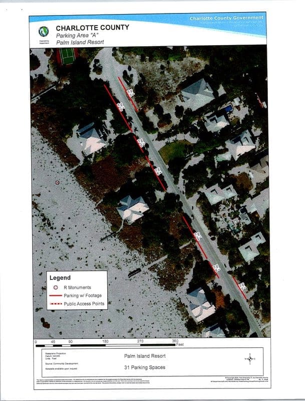
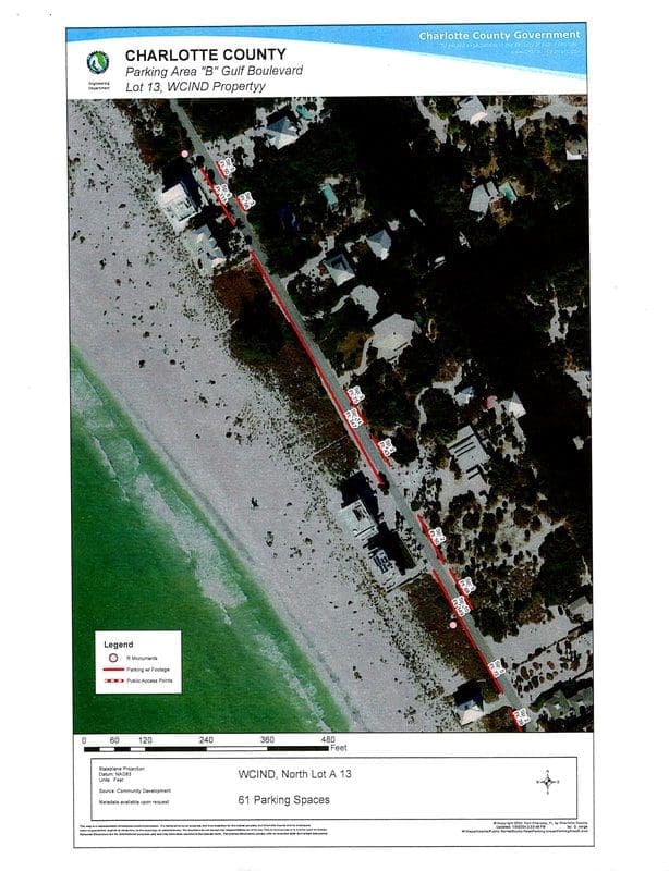
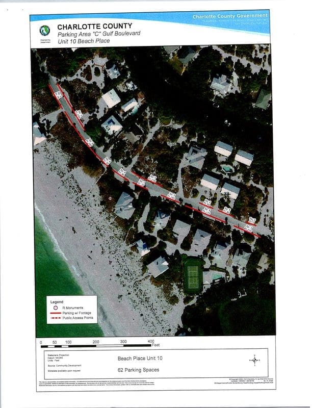
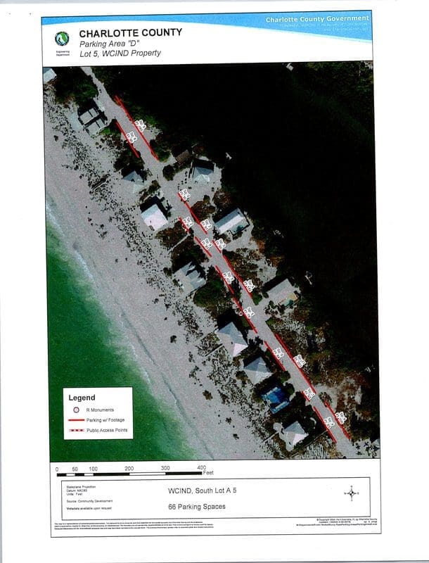
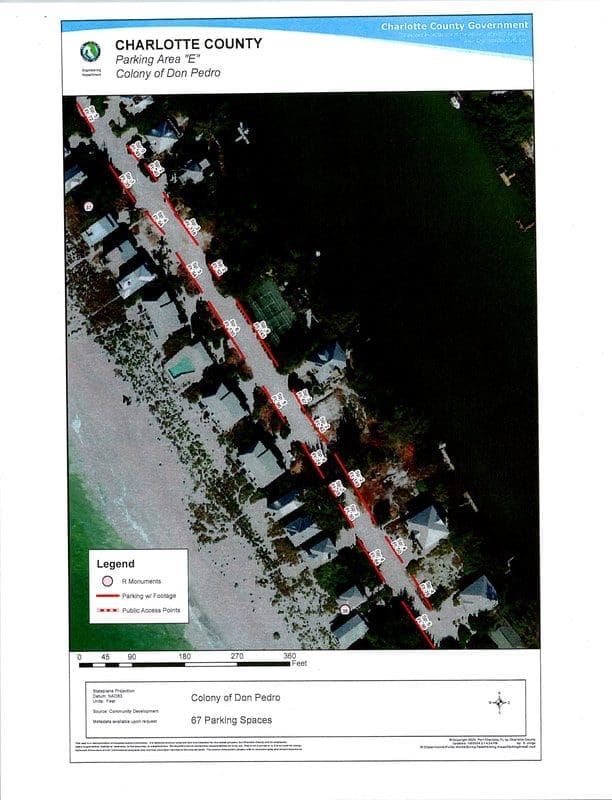
Charlotte County Parking Maps
Below are the Charlotte County Parking Maps for our beaches provided to us at our meeting.
There are 5 areas referenced and each map depicts the location, clearing distance, and the number of parking spaces.
- Parking Area “A” – Palm Island Resort, total of 31 parking spaces.
- Parking Area “B” Gulf Boulevard – Lot 13, WCIND Property, total of 61 parking spaces.
- Parking Area “C” Gulf Boulevard – Unit 10 Beach Place, total of 62 parking spaces.
- Parking Area “D” – Lot 5, WCIND Property, total of 66 parking spaces.
- Parking Area “E” – Colony of Don Pedro, total of 67 parking spaces.
Community Funding:
The total number of parking spaces is 287 according to these maps. For our community to receive funding from the State and Federal government, the beach must have public access. Therefore, it behooves us as a community, to work together in conjunction with our County to continuously maintain beach access, which includes available parking spaces, so we can have continued shared expense to maintain our beautiful beaches.